Thursday, January 21, 2010

Falls Lake Trail in Blue Jay Point County Park

Last March, I visited the portion of the Falls Lake Trail in Blue Jay Point County Park, north of Raleigh in Wake County.

A brief description from their website states:

Blue Jay Point County Park is a 236-acre park located on
the shores of Falls Lake in northern Wake County. Blue Jay Point's mission is to
offer environmental education programming in a natural setting


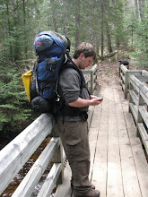
I was very impressed with this relatively new trail, and with this park in general. We spent around an hour wandering the park, with beatiful views of the lake, as well as wildlife.

I am unsure when I will be in the Falls Lake area again, but I am looking forward to seeing more of this trail someday.

My hat is off to the Friends of the Mountains to Sea Trail and to all who helped build this gem of a trail just north of the capital city.

Stay tuned as over the next 3 weeks I will be discussing in great detail my weeklong trek on the Cape Hatteras Beach trail.

Follow these links for more information:

Blue Jay Point County Park: http://www.wakegov.com/parks/bluejay/default.htm
Falls Lake Trail: http://steinbeiser.com/FLT_map/index.html
Friends of the Mountains to Sea Trail: http://www.ncmst.org/

Thursday, January 14, 2010

Getting Back Into The Swing Of Things

329 days.

That is how long I’ve been silent on this blog. You could call it blog fade. I call it super busyness, followed by not thinking about it.

Following my last post in February, my semester in school became a little more intense, and I no longer had time to dream of mountain trails. The MST was not completely off my mind though, because I did plan and execute my trip on the Cape Hatteras Beach Trail, as well as hiking a portion of the Falls Lake Trail. I suppose I will use my next couple of posts to talk about these trips.

I’m not sure what it is about early spring that makes me think about trip planning. I’m guessing it’s the weather and the fact that I’m caught up at school with nowhere to go.

So I am postponing my trip. I still plan on going and hiking the MST, it just may be later than I planned. It won’t be this summer, it probably wont be 2011; however, 2012 is a likely candidate.

Why? Three reasons. School, money, and time. I don’t need to waste anyone’s time talking about the problems posed with each of these things, but they are obviously all factors for the delay.

I am also considering hiking in sections, or biking the roads, rather than a thru-hike attempt. We hiked 14-17 miles a day on the outer banks this spring, and it was tough. I would imagine that it’s something that you would get used to, but it was certainly all day, everyday, and the terrain was flat! I can’t imagine doing 20 miles in the smokies, where I’ve never done more than 12 miles. Anyway, if anyone who has attempted or completed a thru-hike could weigh in on this I would really appreciate it.

Hopefully this first post will get me back into the swing of things and I will update once a week. I am looking forward to telling the internet world about my previous trips, and my dream of the MST.

Thursday, February 19, 2009

Topo maps, Allen De Hart's book, and the Ocracoke Ponies

It's been an eventful week when it comes to planning my cross-state trek.

Yesterday, I finished Allen De Hart's book, Hiking North Carolina's Mountains-to-Sea Trail. It was terrific. I did not think I would be able to read a book where the majority of the information was where to turn next; it turned out to be great.

I already get the feeling that the information in this book will be some of the most valuable to me as I traverse the Tar Heel State.

Also, I finally have the TOPO NC program working on my computer, and it is fantastic. I routed section 1 (Great Smoky Mountains) on the maps, and I was even able to generate an elevation profile. Check it out!
I'm not sure how I will route the off road sections that aren't on the topo map, but I'll figure something out, even if it is just looking at a map and approximating. I welcome any suggestions.


Very Cool!

Finally, last Saturday was Valentine's Day, and this year my girlfriend got something a little unconventional that she absolutely loved. An Ocracoke Pony!

What?

Yes, I actually stumbled upon this while doing research. Cape Hatteras National Seashore manages a small group of ponies on Ocracoke Island. For a small donation, you can "adopt" one of these ponies, and that's exactly what I did. See!

His name is Southwind and he was born on Ocracoke Island in 1982.

Anyway, I'm beginning to gather more information and I feel like planning is really starting to kick into full swing.

Thursday, February 12, 2009

How I got NG Topo! North Carolina for $31.95

Well this is quite the story.

National Geographic makes a product that they call Topo! State Series, that is really terrific. It is USGS topo maps at all 5 levels, right on your computer so that you can edit, print, route, export, etc.

Perhaps the best feature is that if you own a Magellan Triton GPS (like me), the entire map is exportable to the unit, including any edits or overlays that you create.
I have this product for Michigan, and I've been looking to buy the North Carolina version for some time, because it would be useful in planning and executing this trip, but it is on the pricy side ($99.95).

I currently have TOPO 4, but when I bought my Michigan discs it was version 3, so when version 4 came out I simply upgraded; the software can download the new quads and all of the features upgrade.

So I went on eBay, and bought someones version 3 of NC that was missing a disc for $18.95 with shipping. Then I called Nat Geo and ordered a replacement disc for $13.00 with shipping. This is an old version but when I put it on my computer all of the quads updated and it's just like having version 4, except I don't have South Carolina like version 4 does.

Anyway I feel pretty good right now because I just saved a lot of money!

Friday, February 6, 2009

MST Outer Banks Campgrounds

I'm looking into where to camp on my obx trip and having a good time doing it. Here's the lineup I've come up with from north to south.

  • Oregon Inlet Campground, Oregon Inlet (NPS)
  • Ocean Waves Campground, Waves (private)
  • Sands of Time Campground, Avon (private)
  • Frisco Campground, Frisco (NPS)
  • Ocracoke Campground, Ocracoke (NPS)

My total estimated cost for camping is $120, which is not so bad when divided amongst 2 (or 4) people.

The next step is to figure out how to get to these campgrounds from the beach (or trail). Ocean Waves is on the ocean, so that will be easy enough to get to, but some of the other ones I'm sure I'll have to call up and find out where the public access is.

All this preparation is very exciting, I can't wait to go.

Thursday, January 29, 2009

The beginning of a great journey

So although I've been dreaming for a while, this post is the official announcement. I am planning a thru-hike on the North Carolina Mountains-to-Sea Trail.

The MST is a near 1000 mile trail in development stretching from Clingman's Dome, in the Great Smoky Mountains of Western NC, to Jockey's Ridge State Park, in the dunes of the Outer Banks on NC's east coast. Currently, approximately 50% of the route is on designated trail, while the other 50% follows bike routes on North Carolina's highway system.

I have imagined myself doing this trail for a few years now, but the time is nearing and it is time to start the great planning procedure. I am currently about 3/4 through Allen De Hart's book, "Hiking North Carolina's Mountains-to-Sea Trail," and it has been a fantastic read thus far. It seems that one of the greatest difficulties of this trail is the lack of places to stay along it, due to it's nature as a relatively new trail that only a few have thru-hiked. This is certainly an obstacle I am willing to meet.

I plan on starting this trip in early May of 2010 or 2011, and I don't plan on going solo. As for my hiking companion(s), I have a few likely suspects, and we'll see what works out as far as ability and availability.

I am mostly set as far as gear as concerned, but there are a few pieces of equipment that I may need, and this will probably be a point of discussion until I go. I also am going to try to update this journal semi-regularly while out there, which will require me to carry more technology than I have traditionally while backpacking.

The final section of the MST is that of the Outer Banks. Chances are good that I will be hiking this section in May of this year to get a taste for the MST and because I have always wanted to see the Outer Banks.

Anyway, I am very excited to begin the planning stages and to use this blog as a place to gather my ideas, and hopefully get outside opinions.